From the window of our vehicle, we spotted a boda-boda rider carrying half a dozen large yellow water jerry cans stacked on his motorcycle, weaving steadily along a rural road somewhere between Kampala and Jinja. No helmet. Sandals. The load easily doubled the width of the bike. For anyone arriving from Europe, this sight stops you cold — it would be unthinkable on any road back home, illegal in every possible way. But in Uganda, a helmetless rider in flip-flops on a loaded boda-boda is not reckless. It is normal. It is how water gets to homes, how goods reach markets, how an entire informal economy moves.
During my visit in October 2024 — part of a 12-day trip across Uganda — I photographed this exact scene near the Kampala-Jinja corridor, at GPS coordinates 0.2334 degrees North, 31.1350 degrees East. The image is not staged. It is one of six original photographs I took across four days documenting road infrastructure and transport realities in this part of the country. These photos, five of which carry GPS metadata from the camera, form part of the evidence base for this article and cannot be replicated by anyone who has not physically been on these roads.
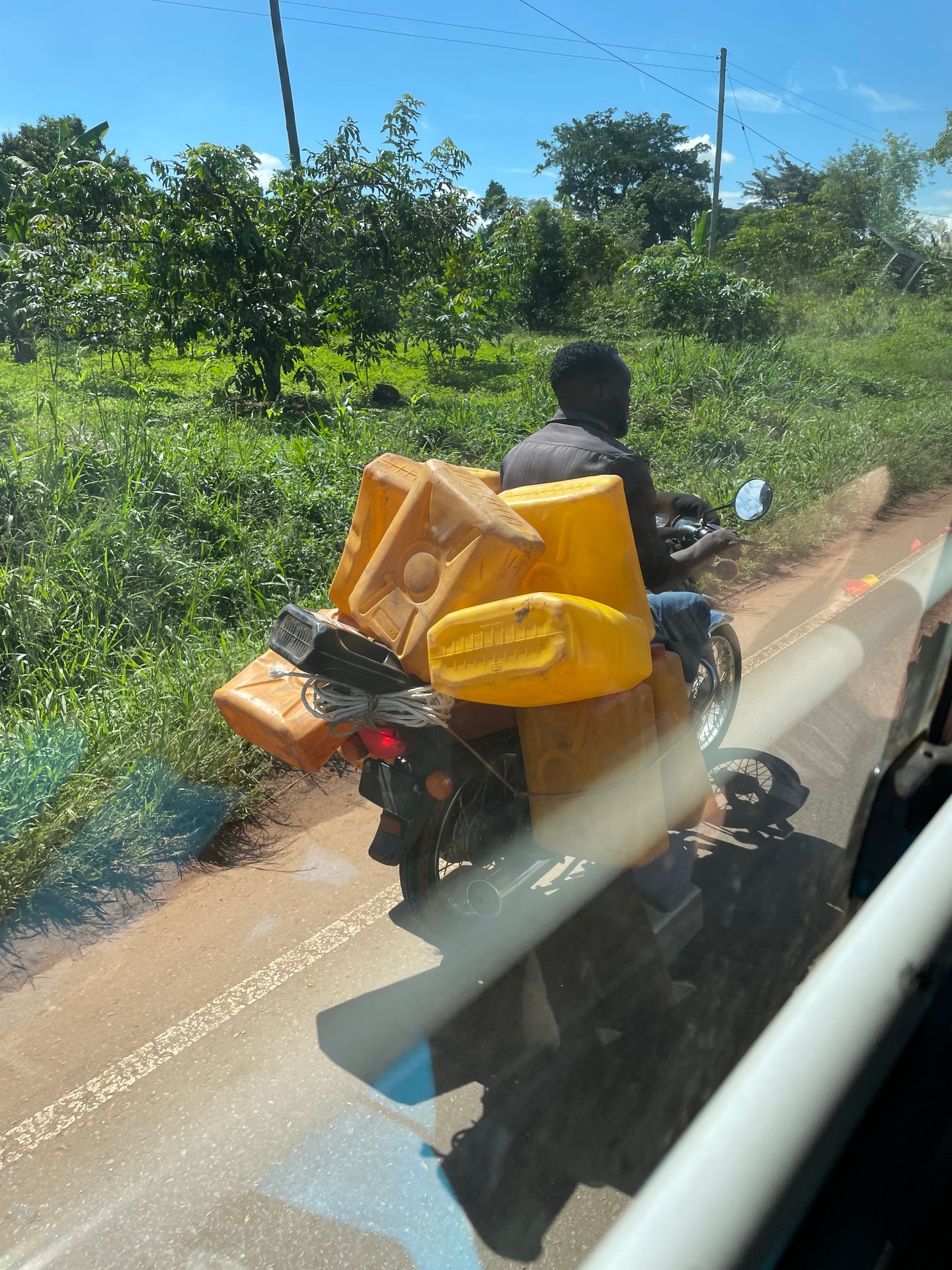
That moment — the loaded boda-boda against a backdrop of green, sunlit countryside — captures the fundamental tension that defines road travel in Uganda. The country's highways serve simultaneously as arterial trade routes for heavy trucks, passenger corridors for safari travellers, commuter roads for minibus taxis, and supply lines for the informal economy that sustains millions. The Kampala-Jinja Highway sits at the centre of all of this. It is Uganda's busiest east-west corridor, linking the capital to the adventure town of Jinja at the source of the Nile, and beyond that, to the Kenyan border. What happens along this highway — the infrastructure built, the rest stops planned, the roads rehabilitated — directly shapes the experience of every traveller heading east from Kampala.
The Kampala-Jinja Highway: Uganda's Eastern Lifeline
The Kampala-Jinja Highway stretches approximately 80 kilometres east from the sprawl of Kampala through Mukono town, past sugar plantations and trading centres, to Jinja — a city that has reinvented itself as the adventure capital of East Africa. The road carries an extraordinary volume of traffic. Heavy goods vehicles transport manufactured goods, fuel, and construction materials between Kampala's industrial zones and the factories around Jinja. Agricultural produce moves in the opposite direction. Matatu minibuses packed with commuters compete for road space with boda-bodas, each carrying passengers, livestock, or improbable stacks of cargo.
For travellers, this highway is often the first major road experience outside Kampala. Those heading to Jinja for white-water rafting on the Nile, bungee jumping, or a visit to the Source of the Nile monument will spend between one and a half and two and a half hours on this route, depending on how quickly they escape Kampala's traffic. The highway passes through several substantial trading centres — Mukono, Lugazi, Namataba — where speed bumps, roadside markets, and pedestrian crossings slow progress. Each of these centres has an informal economy of food stalls, fuel stations, and small shops that serve passing motorists, but none qualifies as a planned stopover facility in any formal sense.
What is missing along this corridor is what tourism planners call a "stopover center" — a dedicated facility designed specifically for road travellers, with clean toilets, food options, rest areas, parking, tourist information, and possibly craft shops or cultural displays. These facilities exist along major highways in Kenya and Tanzania, particularly on routes connecting cities to national parks. In Uganda, however, the concept remains largely undeveloped. Travellers stop where they can — a petrol station with a decent toilet, a known restaurant in Mukono, or simply the roadside when nothing better presents itself.
According to the KYANKWANZI District Development Plan (Phase IV), at least one stopover center is planned for development along the strategic Kampala-Jinja highway corridor in Kyankwanzi District, with construction targeted for 2028 or 2029. This would be a purpose-built facility aimed at serving through-traffic — both the commercial trucks that dominate the highway and the growing number of tourists who use this route to reach Jinja and destinations further east. The development reflects a broader recognition that Uganda's tourism infrastructure needs to extend beyond national parks and lodges to include the roads and rest points that connect them.
Road Conditions I Witnessed: From New Asphalt to Dust and Chaos
Having driven thousands of kilometres across Uganda during 11 visits between October 2024 and June 2026, totalling 22 days on the ground, I have experienced the full spectrum of what the country's road network has to offer. The Kampala-Jinja Highway itself is among the better-maintained routes, largely paved and functional, though battered by heavy truck traffic. But to understand why stopover centers and rest facilities matter so much, you need to see what conditions are like on the other major highways that feed into and connect with this corridor.
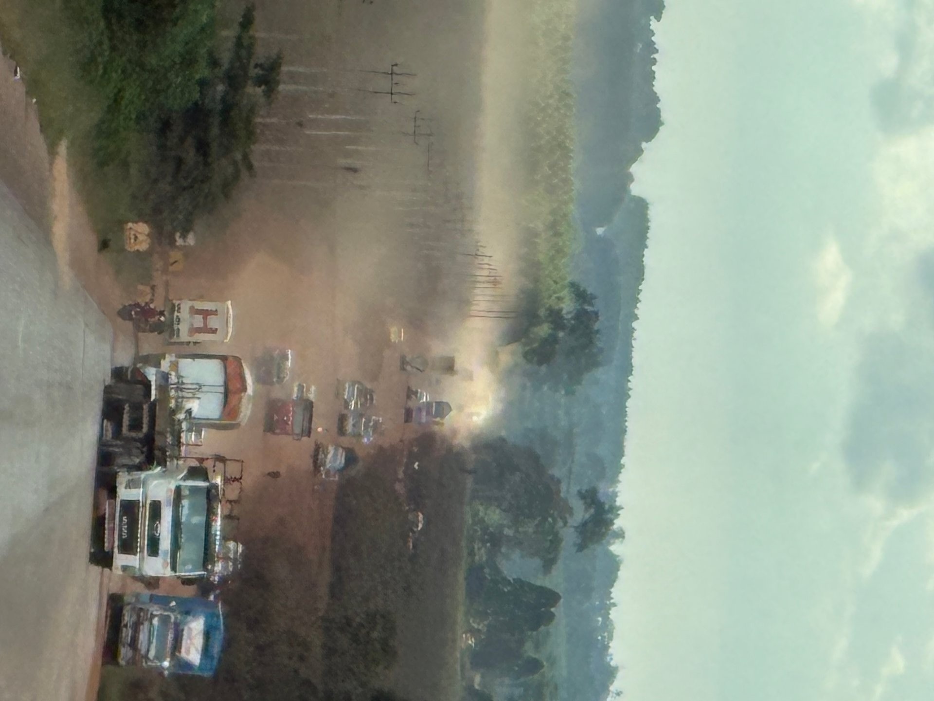
In January 2026, I drove sections of the Masaka Highway — one of Uganda's most important trunk roads, connecting Kampala to the southwestern safari regions including Queen Elizabeth National Park and Bwindi Impenetrable Forest. The road was under active rehabilitation. Long stretches had been stripped back to bare earth, creating a landscape of red-brown dust that coated everything within reach. Trucks, cars, boda-bodas, and pedestrians shared this unpaved surface simultaneously. The dust was so thick that visibility dropped to a few dozen metres when a heavy vehicle passed. For drivers without air conditioning — which includes many local vehicles and virtually all boda-bodas — the conditions were punishing. I photographed this scene at GPS coordinates 0.1061 degrees North, 32.1716 degrees East and again at 0.1065 degrees North, 32.1723 degrees East, both in January 2026.
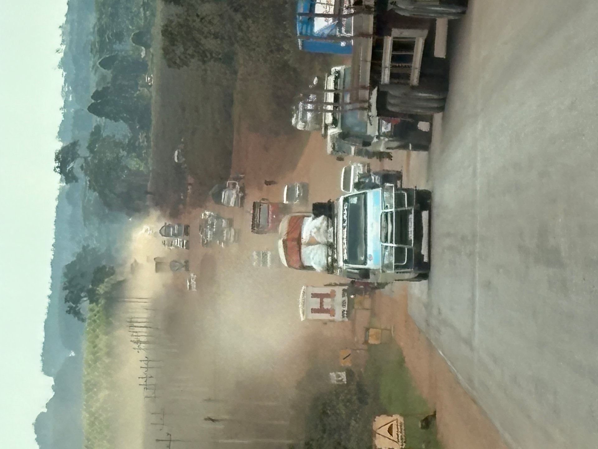
The Masaka Highway under construction was a genuine shock. Even with our vehicle's windows closed and the air conditioning running, fine dust penetrated the cabin. The boda-boda riders had it far worse — exposed to the full force of every passing truck's dust cloud, squinting through grit, breathing in particulate matter that turned their clothes and skin a uniform ochre. Several riders I observed had wrapped scarves or cloths across their faces as improvised masks. This is the daily reality on Uganda's roads when infrastructure investment is underway but not yet complete. It explains why rest stops and clean facilities are not a luxury but a genuine necessity for anyone covering long distances.
The contrast between this scene and what I saw in October 2024 at the entrance to Murchison Falls National Park was stark. There, the Uganda Wildlife Authority had completed a new access road with fresh asphalt, white lane markings, and a modern visitor center at the gate. The road surface was immaculate — better than many European rural roads. This kind of targeted infrastructure investment is happening across Uganda, but unevenly. National parks receive priority because they generate direct tourism revenue. The highways connecting those parks, and the rest facilities along them, lag behind.
Why Stopover Centers Matter for Uganda's Tourism Future
The planned stopover center in Kyankwanzi District represents more than a rest area with toilets and a car park. It signals a shift in how Uganda approaches tourism infrastructure development. Historically, investment has concentrated on two endpoints: Kampala (hotels, conference facilities, the airport) and the national parks (lodges, trails, visitor centers). The roads between these points — the actual travel experience for every tourist who does not fly — have been treated as something to endure rather than enjoy. A dedicated stopover center along the Kampala-Jinja corridor acknowledges that the journey itself is part of the product.
This matters because the Kampala-Jinja Highway is not merely a route to Jinja. It is the starting segment of the eastern circuit that leads to Sipi Falls on Mount Elgon, the Kidepo Valley in the far northeast, and ultimately to Kenya via the Malaba or Busia border crossings. Travellers on these routes can spend five to ten hours in a vehicle. Without planned rest stops, the options are limited to whatever happens to exist at the next trading centre — and the quality varies enormously. I have stopped at petrol stations where the toilets were unusable, and at small restaurants where the food was excellent but reached only by navigating a muddy track off the highway. A formal stopover center with maintained facilities, reliable food vendors, and clear signage would transform this experience.
The Greater Kampala Metropolitan Area — comprising Kampala, Wakiso, and Mukono districts — is the starting point for virtually every road journey in Uganda. According to the GKMA Infrastructure Development Master Plan, the area concentrates over 32 percent of the country's manufacturing activity and generates the vast majority of its commercial traffic. Urban development has sprawled outward from Kampala's centre in a pattern that, as the plan notes, has repeatedly outstripped the capacity of city infrastructure to deliver effective public services. Road congestion in this metropolitan zone is the primary reason that an 80-kilometre drive to Jinja can take over two hours. Any infrastructure investment that eases the transition from urban congestion to open highway — including well-placed rest stops — benefits both commercial transport and tourism.
The concept of stopover tourism is not new in East Africa. Kenya's network of roadside facilities along the Nairobi-Mombasa Highway and the routes to Maasai Mara includes curio shops, restaurants, and cultural centres that have become attractions in their own right. Uganda has an opportunity to learn from these examples while adapting the concept to local conditions. A stopover center along the Kampala-Jinja corridor could incorporate elements that reflect the region's character: displays about the Nile and its source, information about Jinja's adventure activities, locally produced crafts from the Mukono and Jinja districts, and food stalls serving rolex (the ubiquitous Ugandan rolled omelette and chapati) and other local dishes.
[QUOTE: local guide or transport authority official on the need for highway rest facilities]
Transport Realities: Boda-Bodas, Trucks, and the Informal Economy
No discussion of Uganda's road infrastructure is complete without addressing the boda-boda. These motorcycle taxis are the circulatory system of Ugandan transport — they carry people, goods, water, building materials, agricultural produce, and livestock through every city, town, and village in the country. On the Kampala-Jinja Highway, boda-bodas share road space with heavy trucks and speeding matatus in conditions that would be classified as extremely hazardous by any international road safety standard. Yet for millions of Ugandans, the boda-boda is the only affordable and available means of transport.
The boda-boda rider I photographed carrying water jerry cans is not an anomaly — he is representative. Water access in many parts of rural and peri-urban Uganda depends on this kind of improvised delivery. A boda-boda can reach areas that larger vehicles cannot, navigate roads that are impassable for cars, and make deliveries at a fraction of the cost of a truck. The rider's lack of a helmet and his sandals — details that strike European visitors as dangerously irresponsible — reflect the economic reality that helmets cost money, that protective footwear is a luxury, and that the choice between earning a living and staying home is no choice at all.
For tourists, this transport ecosystem is both fascinating and intimidating. Most safari operators and lodge transfer services use private vehicles with professional drivers, insulating travellers from the raw conditions of the highway. But if you look out the window — as I did across multiple trips — you see the full picture. You see the boda-boda loaded with a sofa navigating rush-hour traffic in Mukono. You see the truck driver who has been on the road since dawn, pulling over at a dirt layby to sleep in his cab because there is no rest facility available. You see the matatu conductor hanging out the sliding door, shouting for passengers while the vehicle is still moving. These observations are not criticism — they are documentation of a transport system under enormous pressure, serving a rapidly growing population with infrastructure that has not kept pace.
The Kampala metropolitan area's rapid expansion compounds these pressures. As the GKMA report observes, Kampala's development has consistently outrun its administrative boundaries, leaving large, densely developed areas served by rural-level administrative structures. This means that the peri-urban zones along the Kampala-Jinja Highway — Mukono, Seeta, Namilyango — experience both urban congestion and rural infrastructure gaps simultaneously. A stopover center positioned at the boundary between metropolitan sprawl and the open highway could serve as a transition point, where travellers leave the chaos of Kampala behind and enter the more measured rhythm of the eastern corridor.
What Travellers Should Know: Planning Your Kampala-Jinja Journey in 2026
If you are planning to travel the Kampala-Jinja Highway in 2026 or beyond, here is what my experience across 11 visits can tell you. First, depart early. Kampala traffic builds quickly after 7:00 AM, and the first 15 to 20 kilometres out of the city centre can take over an hour during peak periods. Most safari operators schedule departures before 7:00 AM for exactly this reason. If your lodge or hotel offers an early breakfast, take it.
Second, plan your stops in advance. Until the Kyankwanzi stopover center materialises — and construction has not yet begun as of mid-2026 — you are relying on informal facilities. The Shell and Total petrol stations along the highway generally have functional toilets and small shops. In Mukono town, several restaurants cater to through-traffic and offer reasonable meals. Beyond Mukono, options become more scattered. If you are heading to Jinja for adventure activities, most operators provide a briefing and meal at their base, so you can afford to push through without a long stop.
Third, understand the vehicle situation. Most tour operators and lodge transfer services use Toyota Land Cruisers or similar robust vehicles suited to Ugandan road conditions. These vehicles have air conditioning, which is not a luxury but a practical necessity on dusty stretches. If you are self-driving — which is possible but only advisable for experienced drivers familiar with East African road culture — ensure your rental vehicle is in good mechanical condition. Breakdowns on the Kampala-Jinja Highway are common, and recovery services are limited to what you can arrange by phone.
When I visited Murchison Falls National Park in October 2024, I was struck by the quality of the new entrance road — freshly paved, properly marked, with a modern visitor center at the gate. It was a brief stop, but it demonstrated what targeted infrastructure investment can achieve. The access road felt like a different country compared to the stretches of unpaved highway I had driven to reach it. This contrast is instructive: Uganda is capable of building excellent road infrastructure when the political will and funding align. The question for the Kampala-Jinja corridor is whether stopover facilities will receive the same level of investment as national park entrances.
Jinja itself rewards the journey. The town sits at the point where the Nile flows out of Lake Victoria, and the area around Lake Bujagali offers a range of accommodation from budget campsites to the Jinja Nile Resort, located four kilometres northeast of the town centre along the Jinja-Budondo Road. According to the Reisefuehrer Uganda (2020 edition), double rooms including breakfast start from around USD 235, with amenities including a swimming pool, fitness centre, and direct river frontage. The western bank of the Nile and the stretch downstream from Bujagali host additional lodges and adventure camps catering to rafting, kayaking, and bungee jumping visitors.
The broader context of infrastructure development across Uganda is important for understanding why the Kampala-Jinja corridor matters. Uganda divides its territory into six wildlife zones — Sango Bay, Kafu, Muzizi, Aswa, Central, and Kyoga — according to the State of Wildlife Resources in Uganda report published in 2026. The Kampala-Jinja Highway falls within the Central zone, which also encompasses the Lake Victoria shoreline and the source of the Nile. Tourism infrastructure in this zone serves not only adventure travellers heading to Jinja but also visitors to the Ssese Islands, Ngamba Island Chimpanzee Sanctuary, and the various cultural and historical sites around the Kampala metropolitan area.
I visited Ngamba Island during my October 2024 trip and photographed the sanctuary's perimeter fence — a robust metal barrier that marks the boundary of the chimpanzee enclosure. The fence looks harsh, even unsettling, when you first see it. But behind it lies a forested area that represents freedom for chimpanzees rescued from captivity and appalling conditions. The sanctuary, located on Lake Victoria and accessible by boat from Entebbe, is one of the attractions that a well-planned stopover network could promote. Currently, many tourists are unaware of Ngamba Island because there is no tourist information infrastructure along the roads connecting Kampala to the lake. A stopover center with regional attraction information could change that.
My most recent visits in 2026 also took me to Bwindi Impenetrable Forest, where the Gorilla Bluff Lodge in Buhoma exemplifies the kind of infrastructure challenges that Ugandan lodges face in remote locations. The lodge is built on a steep hillside, and reaching the main building from the guest rooms involves climbing rustic wooden stairs fashioned from massive tree trunks. These steps, which I photographed at GPS coordinates -0.9794 degrees South, 29.6168 degrees East in January 2026, represent the handcrafted resourcefulness that defines Uganda's hospitality sector outside the major cities. Building comfortable accommodation on a forested mountainside requires a different kind of infrastructure investment than constructing a highway rest stop, but both reflect the same underlying challenge: Uganda's tourism product is spread across difficult terrain, and connecting visitors to it requires sustained investment in roads, facilities, and services.
The Equator Assessment and Brand Manual, a government planning document, identifies several potential tourist service points along major Ugandan highways, including locations near Lake George in Kamwenge District. These sites offer what the document describes as "virgin area with opportunity to set up tourist services" including accommodation, restaurants, and recreation facilities. The Kampala-Jinja corridor, by contrast, already has heavy traffic and established trading centres — what it lacks is the intentional planning that transforms a busy highway into a tourism-friendly travel route.
For travellers reading this in 2026, the practical reality is straightforward: the Kampala-Jinja Highway is a functional, mostly paved road that will get you from the capital to Jinja in under three hours. The drive is safe with a competent driver, manageable for self-drivers with African road experience, and scenic enough to be interesting rather than tedious. The absence of formal stopover centers is a gap, not a dealbreaker. Bring water, plan your toilet stops around petrol stations, and enjoy the views of sugar plantations, roadside markets, and the occasional boda-boda carrying an improbable load. Uganda's road infrastructure is evolving — not as fast as the tourism sector would like, but in a direction that will eventually transform the highway experience from mere transit into something closer to a journey worth taking.